
Unveiling the secrets of methane: monitoring emissions using HySpex SWIR cameras
When it comes to climate change, carbon dioxide has long taken the spotlight. However, there's another player in the game that is rapidly gaining attention as a major driver of anthropogenic climate change: atmospheric methane (CH4). Its relatively short lifespan of approximately nine years has placed methane in the limelight as a potential target for near-term climate change mitigation. By reducing methane emissions, we have the opportunity to witness significant climate effects within a matter of decades. To better understand and monitor methane emissions in line with the goals of the Paris climate accord and its monitoring, reporting, and verification requirements, scientists have turned to spectroscopic remote sensing. This method allows the observation and tracking of the release of methane into the atmosphere. Among the various sectors contributing to methane emissions, the fossil fuel industry stands out, accounting for over 30% of global anthropogenic CH4 emissions. Tackling leakages in this sector presents not only environmental benefits but also economic advantages. The emissions from this sector are predominantly concentrated in large point sources, making them prime targets for monitoring efforts.
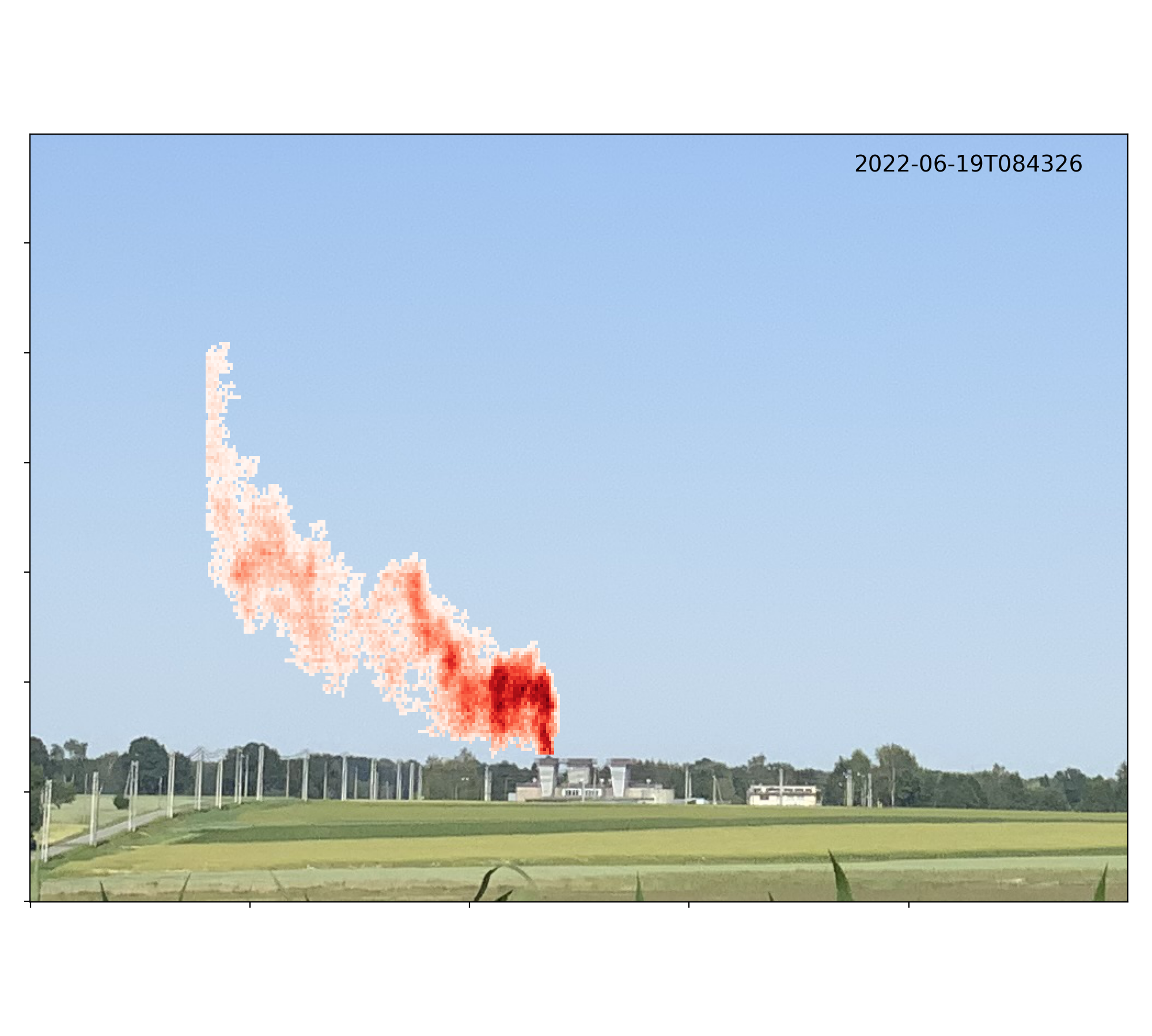
The image shows a coal mine ventilation shaft which emits methane. Methane is invisible to the human eye, yet the HySpex camera reveals the plume emanating from the left shaft. Darker colours correspond to a higher atmospheric methane content.
Up until now, imaging spectrometers mounted on aircraft and satellites have played a crucial role in detecting methane plumes. By capturing detailed images of these plumes, researchers have successfully discovered previously unknown leaks, both accidental and catastrophic, and quantified the emission rates of individual facilities and groups of facilities in the fossil fuel and waste sectors. The study by Knapp et al. [1] has taken this technology a step further by directly measuring the dynamics of methane plumes and emissions from coal mine venting in the Upper Silesian coal basin, Poland, a hotspot of CH4 emissions in Europe, utilizing a ground-based imaging spectrometer from HySpex. Its stationary deployment allows for repeated imaging of a single target, offering monitoring on a timescale of minutes that surpasses traditional area mapping. This method can be deployed from a kilometer-distance from the target, offering a quantification of the released CH4.
The field instrumentation comprises a HySpex SWIR-384 hyperspectral camera and a Windranger 200 wind-lidar. The camera is mounted on a rotation stage, allowing for horizontal scanning of the target area. It captures skylight from a shallow elevation angle recording the SWIR spectrum between in the shortwave infrared (SWIR, 950 nm, and 2500 nm) with a sampling distance of 5.45 nm. Simultaneously, the Windranger measures wind direction and velocity at various heights, see Figure 1 for the field setup. With a spatial resolution of approximately 0.8 m x 0.8 m, a single HySpex scan takes around 60 seconds. Over a span of four days, scans were collected continuously at roughly 1-minute intervals, supplementing the images with wind data, temperature, pressure, and other meteorological measurements.
Using a matched-filter algorithm, methane plumes above the facility were identified. By combining this information with wind data, Knapp et al. were able to estimate emission rates, see Figure 2 for an example. The captured data reveals significant variability in methane emissions on timescales ranging from minutes to days. This technique complements observations from aircraft and satellites, which cannot capture source variability at such short intervals. It also complements other leak detection methods, such as OGI (optical gas imaging) and thermal infrared spectrometry. The presented setup enhances state-of-the-art emission monitoring by remotely measuring the dynamic emissions of localized sources with a minute-by-minute resolution. By harnessing cutting-edge technology and capturing emission dynamics, we move closer to a comprehensive understanding of methane's role in climate change and the implementation of effective mitigation strategies.
As we strive to address climate change effectively, every piece of the puzzle matters. The ability to monitor methane emissions with such precision not only enhances our understanding of the problem but also equips us with vital information to implement targeted strategies.
HySpex offers a varied selection of turn-key solutions for mining and raw material-related studies as well as other scientific and industrial applications. Contact us at hyspex@neo.no to discuss your application and requirements with our specialists.
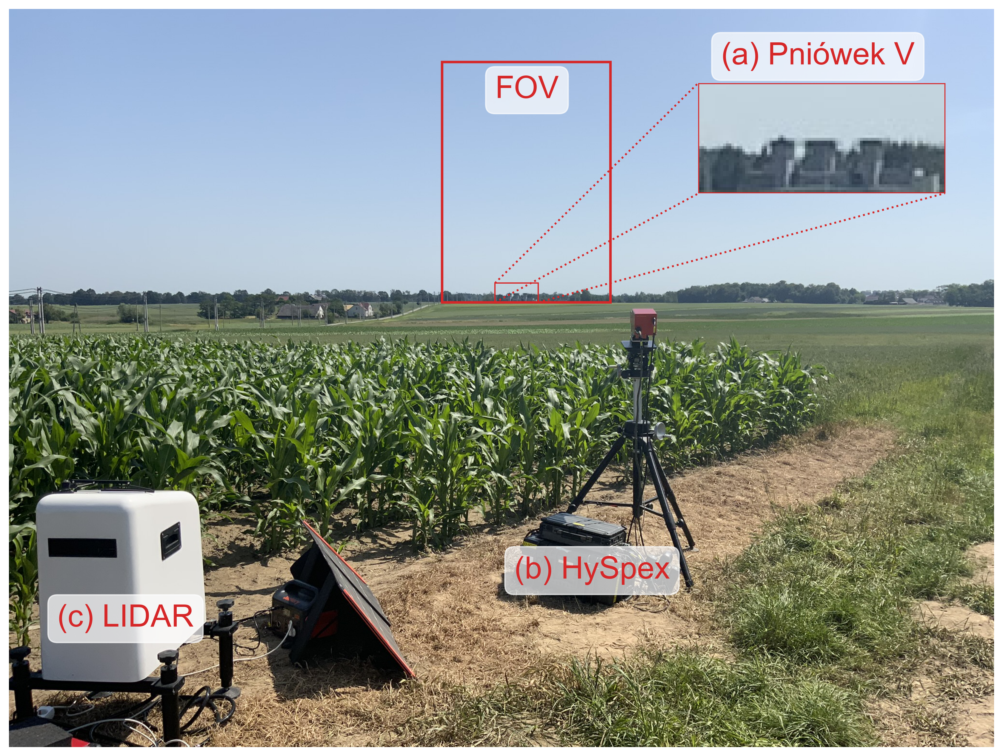
Figure 1: The instrumental setup. The inset shows the three ventilators of the coal mine shaft (a). The HySpex SWIR-284 camera (b) and the wind-lidar (c) are deployed at 1 km distance, the red rectangle shows the camera field of view (FOV).
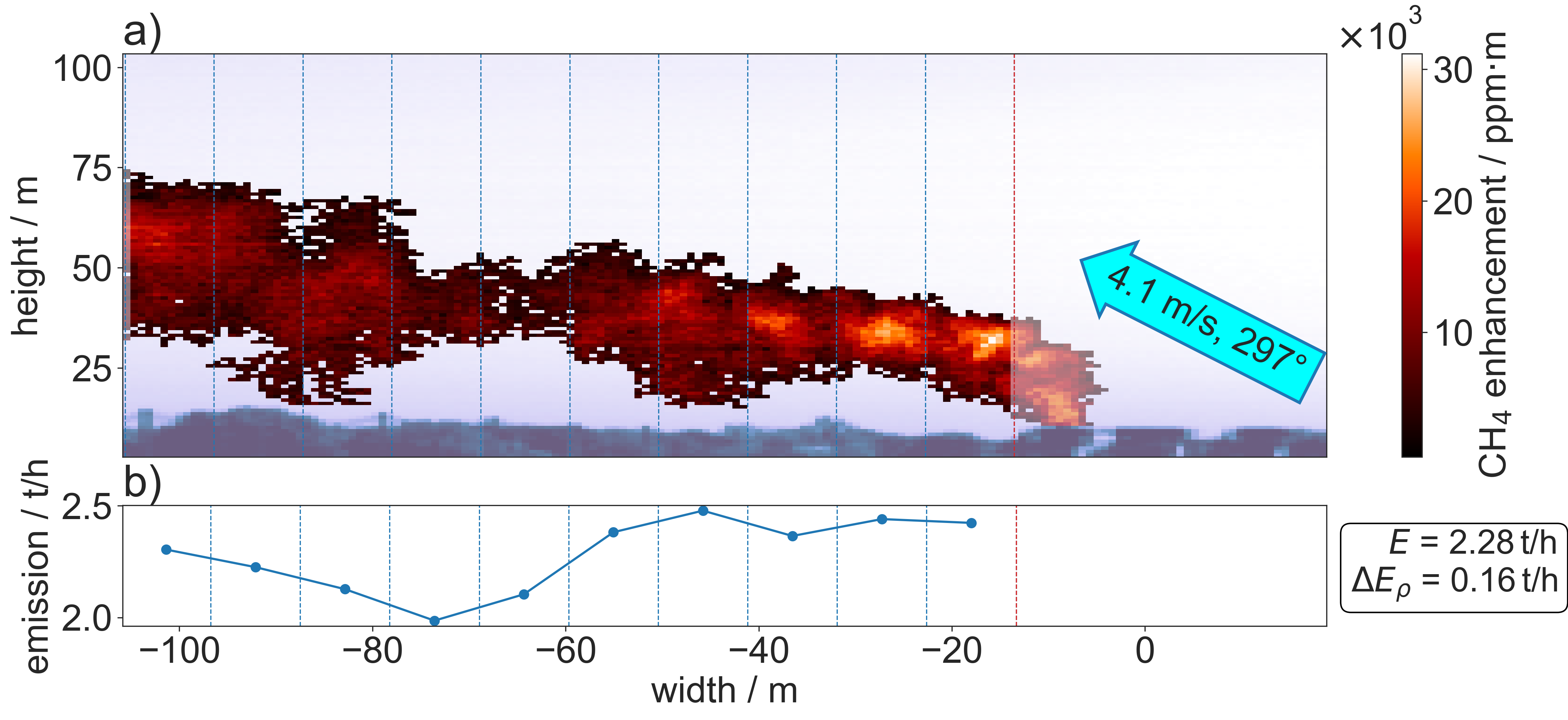
Figure 2: a) Example image from 19 June 2022 at 08:45 UTC. The image shows the CH4 plume (red to orange color coding) in front of the background reflectivity (blue to white color coding). Emission estimates are based on the highlighted plume parts. The arrow indicates the horizontal wind direction (upward component = wind from the back, leftward component: wind from the left) measured clockwise to the lines-of-sight. Wind speed corresponds to the one at mass-weighted mean plume height. B: Emission estimates using growing box sizes for calculating MCH4 /d, where d is measured from each blue line to the red one, i.e. d (and MCH4 ) increases from right to left. The mean and standard deviation among the emission estimates with growing box sizes are indicated by E and ∆Eρ and are used for estimating the uncertainty of MCH4 /d.