
Hyperspectral Imaging for Airborne Base-Metal Exploration

Mineral exploration increasingly relies on spectral data to identify alteration minerals, lithological contacts and surface expressions of ore systems.
A study by Schodlok, Frei and Segl (2022) provides a practical example of how high-quality airborne HySpex data can support exploration in a complex base-metal district, while also showing how the same airborne dataset can be used to evaluate the potential and limitations of current and future hyperspectral satellite missions.
The Gamsberg deposit forms part of the Aggeneys ore district and is a major Zn-Pb-Cu system. At the surface, gossans dominated by hematite provide an important exploration proxy for the underlying mineralization. This makes the area a useful test site for evaluating whether hyperspectral mineral maps can connect surface mineralogy with the geological units that host mineralization.
The Project at a Glance
♦️ Application: Airborne VNIR-SWIR hyperspectral mapping for lithological discrimination and base-metal exploration targeting.
♦️ Deposit Setting: Broken Hill-type Zn-Pb-Cu base-metal system at Gamsberg, part of the Aggeneys ore district in the Northern Cape Province of South Africa.
♦️ Scale Comparison: Airborne HySpex data were also used to simulate EnMAP-like spaceborne hyperspectral data at 30m pixel size, enabling comparison between detailed airborne mapping and regional satellite-scale products.
♦️ HySpex Data: 18 airborne flight lines acquired in 2015 with legacy HySpex VNIR-1600 and SWIR-320m-e systems, covering 400-2500 nm at 2.5 m ground sampling distance.
♦️ Analysis Approach: Spectral feature fitting using reference spectra for muscovite, illite, kaolinite, hornblende and hematite from the USGS Spectral Library v7, supported by geological and field validation.
HySpex Airborne Acquisition and Processing
The airborne survey consisted of 18 flight lines acquired with HySpex VNIR-1600 and SWIR-320m-e instruments. The VNIR and SWIR data streams were radiometrically corrected, orthorectified, atmospherically corrected and co-registered into a single VNIR-SWIR cube. The final airborne product provided 2.5 m ground sampling distance, with LiDAR-derived surface information available at 1 m resolution.
Schodlok et al., 2022, used spectral feature fitting to compare image spectra with diagnostic absorption features from reference minerals. This workflow focused on minerals and spectral classes relevant for geological mapping in the area: muscovite, illite, kaolinite, hornblende, hematite and an additional iron-enriched class described as an “Fe anomaly”.
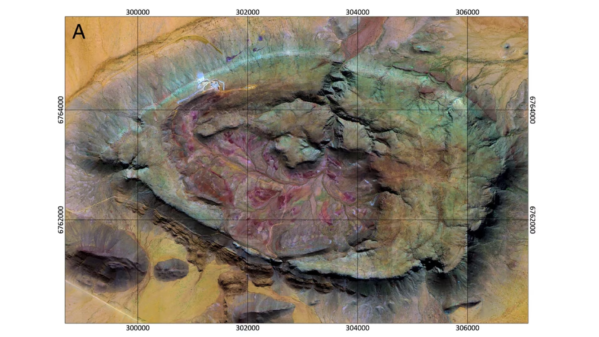
Figure 1: False-colour HySpex composite of Gamsberg using 2204, 900 and 470 nm as RGB channels. The airborne VNIR-SWIR data reveal lithological and alteration patterns across the inselberg at high spatial detail. Adapted from Schodlok et al. (2022), licensed under CC BY 4.0 (http://creativecommons.org/licenses/by/4.0/.); cropped/reused for this application note.
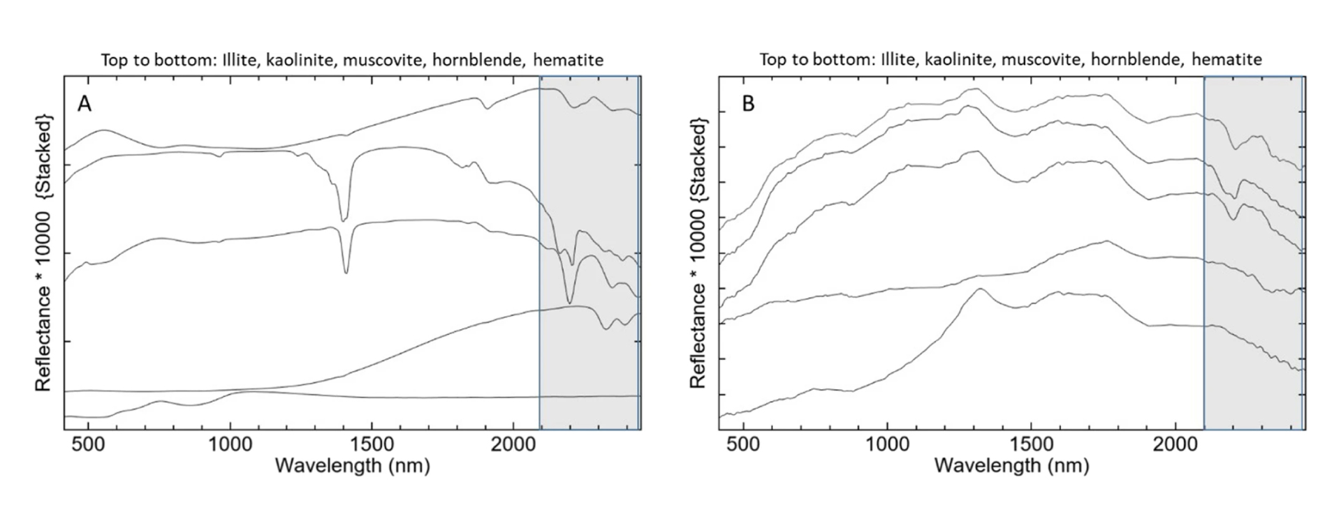
Figure 2: Left: Reference spectra from the USGS Spectral Library v7 (Kokaly et al., 2017) compared with airborne HySpex image spectra for selected mapped minerals on the right. The grey region highlights the SWIR absorption interval used for spectral feature fitting. Adapted from Schodlok et al. (2022), licensed under CC BY 4.0; cropped/reused for this application note.
Mineral Mapping Results
The airborne classification produced mineral maps that are directly meaningful for geological interpretation. Muscovite, illite, kaolinite and hornblende follow major lithological units, while hematite and the Fe-anomaly class highlight gossanous and iron-enriched zones. In the study, the hematite-rich gossan distribution is particularly important because it is used as a surface proxy for the Gamsberg lead-zinc mineralization.
The high spatial resolution of the airborne HySpex data is important. At 2.5 m pixel size, narrow lithological and alteration patterns can be mapped with more spatial detail than is possible with 30m satellite data (see the publication for a comparison to the simulated EnMap data). The study also shows that some mineralogical differences, such as the distinction between well crystalline and poorly crystalline kaolinite, are visible in the airborne data but not reproduced in the simulated EnMAP product.
The airborne HySpex data enables:
♦️ Mapping of major lithostratigraphic units connected to Zn-Pb-Cu mineralization in the Aggeneys ore district.
♦️ Identification of hematite-rich gossans and Fe-enriched zones as surface proxies for ore-related geological units.
♦️ Discrimination of key alteration and lithological minerals.
Airborne Detail and Satellite Scalability
A central outcome of the study is the relationship between airborne and satellite-scale hyperspectral mapping. Simulated EnMAP data at 30 m reproduced the major spatial distribution of hematite-rich gossans, kaolinite and other mineral patterns. This supports the use of hyperspectral satellite data for regional exploration screening and target generation in the future. However, the coarser satellite pixel size creates stronger spectral mixtures and broader mapped patches, reducing the level of detail available within mineralized zones.
For exploration workflows, satellite hyperspectral data is a useful tool to identify prospective areas across large regions, while airborne HySpex data is able to provide the spatial detail needed for deposit-scale interpretation, field targeting and validation.
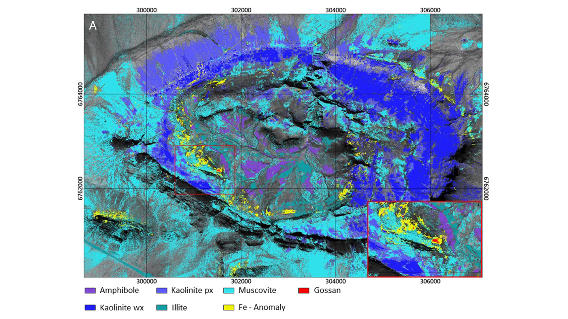
Figure 3: Mineral classification of the airborne HySpex data at Gamsberg. The map shows muscovite, illite, kaolinite, amphibole, gossan and Fe-anomaly classes over the airborne dataset. The Fe-anomaly and gossan classes mark iron-enriched zones that are relevant as surface expressions of base-metal mineralization. Adapted from Schodlok et al. (2022), licensed under CC BY 4.0; cropped/reused for this application note.
Conclusion
The Gamsberg study demonstrates that airborne HySpex VNIR-SWIR data provides geologically meaningful mineral maps for base-metal exploration.
The combination of high spatial resolution, continuous spectral coverage and validated mineral mapping allowed the researchers to identify lithological units, alteration minerals and gossan-related iron anomalies associated with Zn-Pb-Cu mineralization. The work also shows that airborne hyperspectral data are highly valuable for testing and validating satellite-scale products, particularly as EnMAP, CHIME and other hyperspectral missions increase access to spaceborne mineral mapping data.
Interested in learning more about how hyperspectral imaging can be used in your airborne base-metal exploration?
Get in touch with one of our hyperspectral specialists by filling out a form on our contact page! We offer many turnkey solutions for mining and raw material-related studies as well as other scientific and industrial applications.
Sources:
- Citation: Schodlok, M.C., Frei, M. and Segl, K. (2022). Implications of new hyperspectral satellites for raw materials exploration. Mineral Economics, 35, 495-502. https://doi.org/10.1007/s13563-022-00327-1
- Figure licence: Figures adapted from Schodlok et al. (2022), published under CC BY 4.0. Reuse requires attribution, citation of the source, a link to the licence and indication of changes.
- Reference spectra: Kokaly RF, Clark RN, Swayze GA, Livo KE, Hoefen TM, Pearson NC, Wise RA, Benzel WM, Lowers HA, Driscoll RL, Klein AJ (2017) USGS Spectral Library Version 7 Data Series. Reston, VA, p 68
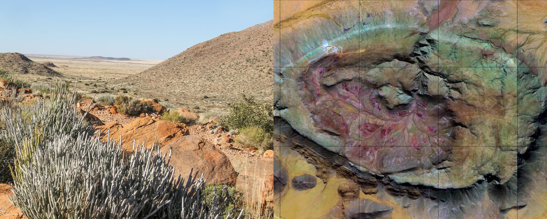
- Cover photo: Marieke - View over the plains in the Aggeneys area of the Northern Cape of South Africa on a clear winter’s day with the bare branches of the euporbia Mauritania in the foreground [Photograph]. Adobe Stock. File #1887574836